Linde Ex & Aebele Trijsburg: What if...

Linde Ex and Aebele Trijsburg are working on 'What if', an investigation into the future of the northern landscape, assigned by SIGN and Noorderlicht. They keep each other informed through this blog.
30 August, 2020
Hi Linde,
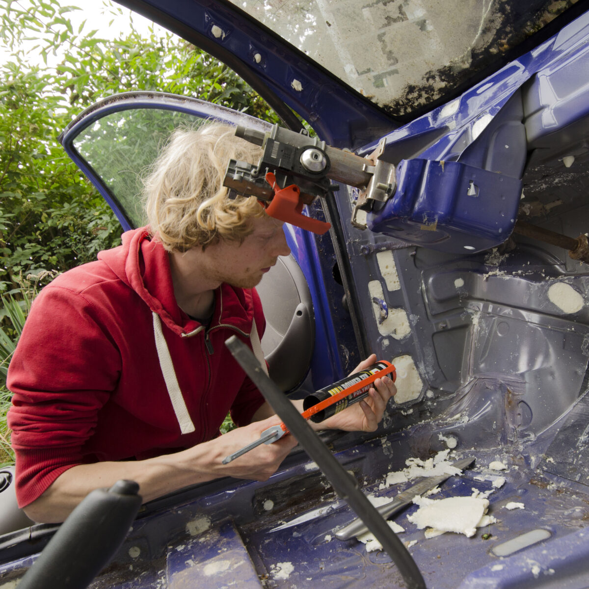
Today I will fill the Ford Ka with water. I just hope the water doesn’t escape from all sides. A week ago, I thought the work was almost done and, in my enthusiasm, I replaced the dashboard and the front seat. Yesterday, after some deliberation, I removed them both again to reinforce a number of plugged holes with a layer of sealant. On the one hand, I now feel that I have done everything I can to make this project a success, on the other hand, I keep thinking: ‘a car is not made to be filled with three thousand litres of water, anything can go wrong.’
We will see.
Aebele
—
29 June, 2020
Hi Linde,
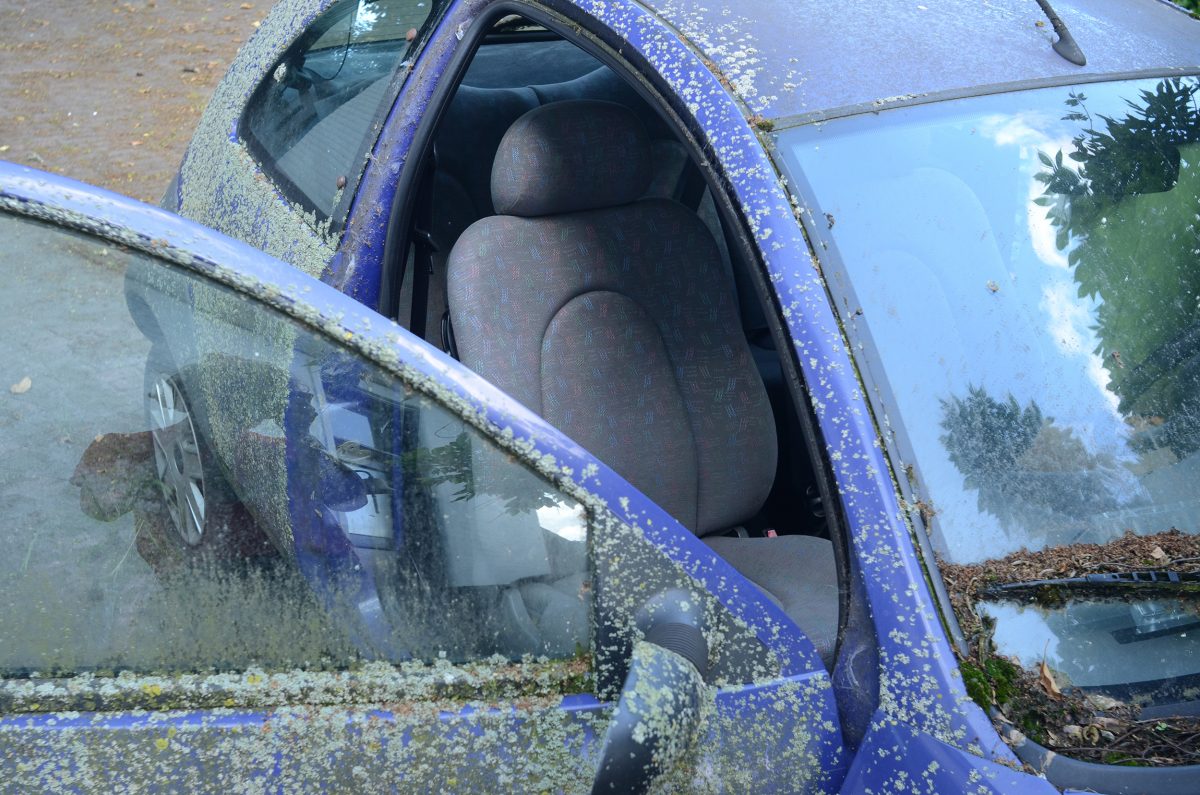
Fantastic that your models are now in place. I’m very curious what the tides will do with it. I am currently removing the interior of a Ford Ka. The car has been able to ‘ripen’ outside for a long time and is completely covered with lichens, a nice symbol for the passage of time. The moss reminds me a lot of your research in which you play with the scale of the models and the surrounding landscape: from nearby the mossy bodywork looks like a landscape.
As you know, I plan to completely waterproof the car inside so I can fill it up with water. Just removing the interior is already an adventure. Under the carpet I found a green pencil and fifty cents. I just hope I can close all the gaps. When it does, it will hopefully yield interesting images.
Regards,
Aebele
—
20 June, 2020
Dear Aebele,
At the moment I am working on the project in different ways; reading and researching, material experiments with clay, silt and other materials and physical work.
Last week I placed two scale models. At the IJsselmeer in an old pool that in earlier days was used to purify water, now filled with fresh water. It is located right next to the coast of what was once the Zuiderzee, just before the low dike. So sometimes this area also flooded. I also placed a model in a storage area in the harbor of Lauwersoog. Two very different places and two very different experiences.
The pool at Hege Gerzen on the IJsselmeer was dry, unlike the last time I was there. So I am very curious how this will work out. Maybe I should leave the model much longer than I thought for the influence of water and location to really play a role.
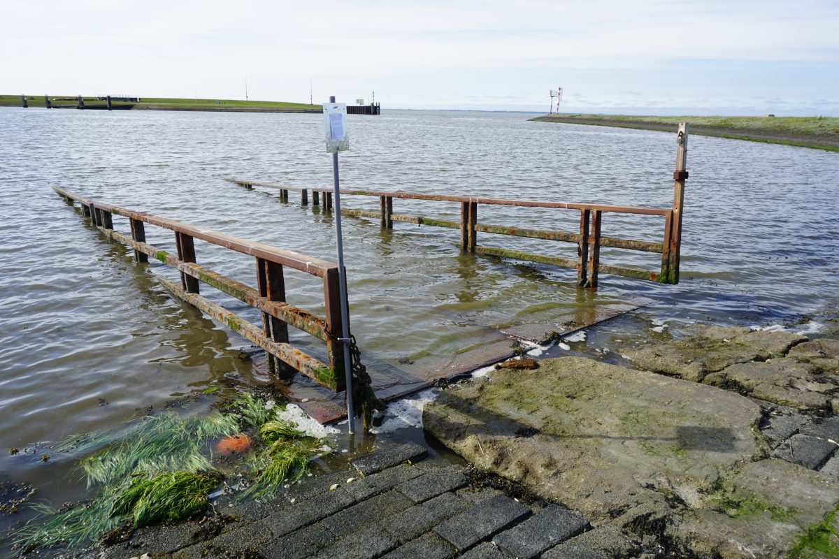
The reservoir in Lauwersoog (photo) is completely different, when the tide came in I could see the extremely fast change. The place was initially largely filled with silt, a kind of semi-circular beach between the piers where you can sink in to your knees. But when the tide came in, I quickly saw that the place I had in mind would be absolutely too intense for the model. The water came up very fast and the waves were extreme for the low model. Exactly what I had hoped for. An extreme enlargement of the effect of tides and water on an environment. Eventually I found a place that is not so extreme that the model would immediately be washed away, but where the tides do have an influence.
Greetings,
Linde
—
11 June, 2020
Hey Linde,
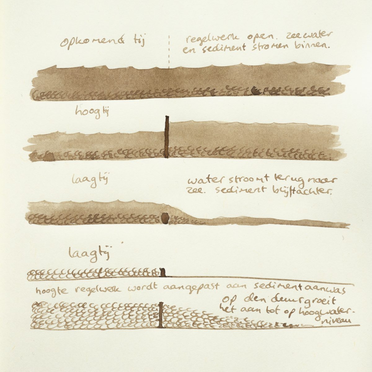
In Holwerd, there are plans to open the dyke and lead seawater to a new artificial lake. The initiators want to prevent runoff, but also create a new tidal area with space for birds and fish. An ingenious framework is placed in the dyke so that the tides do enter, but the sediment does not. The sediment is undesirable for recreational sailing.
I am just on the other hand for a framework to bring ín sediment, to regenerate areas inside the dykes that have fallen in relation to sea level due to settling and reclamation. The idea is similar to the experiment on the Danish island of Funen, which you pointed out to me. The difficult thing about our situation is that the land behind the dyke is often lower than the sea at high tide. That is why I came up with an inverted version of the framework for Holwerd, that regulates sludge and seawater (see drawing). It is only a simple sketch, but it might mean something for the elevation of the land, for all kinds of tidal plants, tidal birds and animals that live in the silt.
See you,
Aebele
—
June 3, 2020
Hi Aebele,
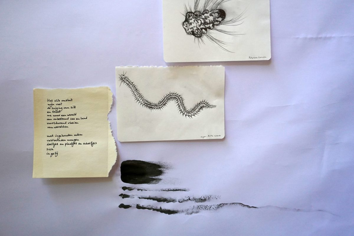
I am in contact with a number of marine biologists who can help me with my research on the benthic animals that may be included in my models. When I was working on the clay we dug up in Groningen, I already saw an interesting specimen, I am curious about what it is…. I am now drawing many common benthic animals, how they live and affect the coast. (image). Did you know, for example, that the sawyer takes grass seeds into his tunnel to germinate there? Playing farmer …
Last week I went to Hege Gerzen, on the IJsselmeer in Friesland, to take a look at a location that is now used for recreation. Interesting: there is a natural height in the landscape, created in the Ice Age, which runs quite far into the country and on one side turns into a landscaped dike. There are two locations I consider for placing a scale model there; one on the IJsselmeer itself (Research what if … 6.jpg) and one just off the coast, in a natural pool that has been around for a long time and was used to purify water. I will keep you informed, and I am very curious about your progress.
Warm regards,
Linde
—
May 26, 2020
Hey Linde,
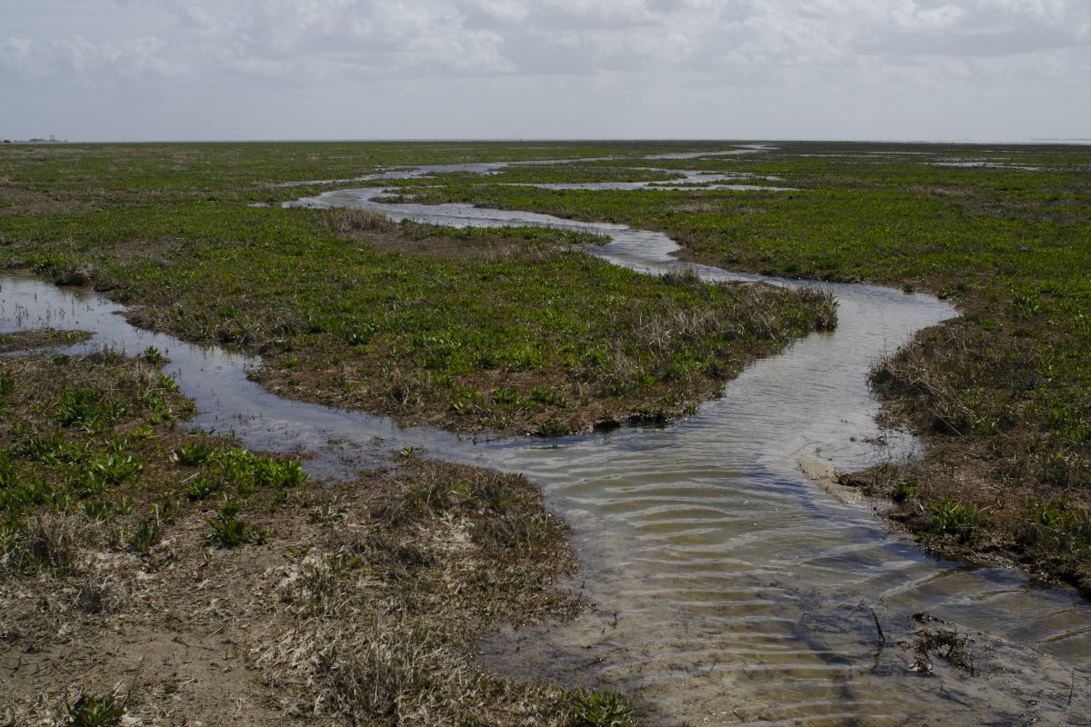
Last Saturday I went to Schiermonnikoog to take a look at the salt marshes. As a bizarre coincidence I met Carlien Bootsma on the ferry. She has written a series of articles on sea level rise on the mudflats. Carlien gave me the telephone number of the ranger of Schiermonnikoog. She could tell me exactly where to go.
I first visited the young salt marsh at Het Rif (photo). It was not swampy, as I expected, but rather passable. A lot of samphire and sea lavender grew there. The speed at which the seawater crept onto the land at high tide made a big impression on me. I also went to the salt marsh near Kobbeduinen. Apparently, the landscape lends itself well to extensive livestock farming; at a wide tidal channel I ran into a lot of cows.
The internet page you sent suggests that an open connection to the sea is sometimes better for land conservation than dikes. Salt marshes, unlike polders, can rise with sea level. Research by Bureau Waardenburg showed that salt marshes can also store more, faster and longer CO2 than forests.
Regards,
Aebele
—
May 19, 2020
Dear Aebele,
After our wanderings through Groningen and Friesland, my work is now starting to take shape. At the moment I organize all my findings about life on mounds and terps, the benthic animals that live in the salt marshes, material tests and loose thoughts on a large sheet of paper in my studio.
Landscape historian Mans Schepers supplied me with good images of historical mounds and terps and combined with my own findings I have made two clay models (photo) to place on the coast, with clay that we excavated in Groningen. The models are based on a radial mound where the houses were arranged around a float (pond for fresh water). This simple model will be the basis of the models that I hope to install soon.
I am very curious about your research into the history of the landscape.
Warm regards,
Linde
—
Here’s more on the project.
